Scientists at the Planetary Science Institute (PSI) in Tucson, Arizona, have found further evidence for the large role that water has likely played in shaping the martian landscape.
Their results, which will be published in Icarus, provide strong evidence that multiple wet and/or icy climate cycles have shaped the topography of the planet’s large craters. Icarus is the journal of the American Astronomical Society’s Division of Planetary Sciences.
“Studying crater degradation in potentially ice-rich environments is vital to understanding the geology of craters and their surroundings, as well as for determining whether the ice comes from the atmosphere or from below the ground,” said Daniel Berman, a PSI associate research scientist and lead author of the paper.
Berman, along with PSI Senior Scientist David Crown and PSI Research Scientist Leslie Bleamaster III, surveyed the geologic features in two sets of mid-latitude craters. Each set included about 100 craters, with the first set in the Arabia Terra region of the northern hemisphere and the second set in an area east of Hellas basin in the southern hemisphere.
The researchers selected craters that are greater than 12 miles (20 kilometers) in diameter that have been completely or nearly completely photographed by cameras on various spacecraft, including the Mars Odyssey THEMIS VIS camera, the Mars Global Surveyor Mars Orbiter Camera, and the Viking Orbiter cameras.
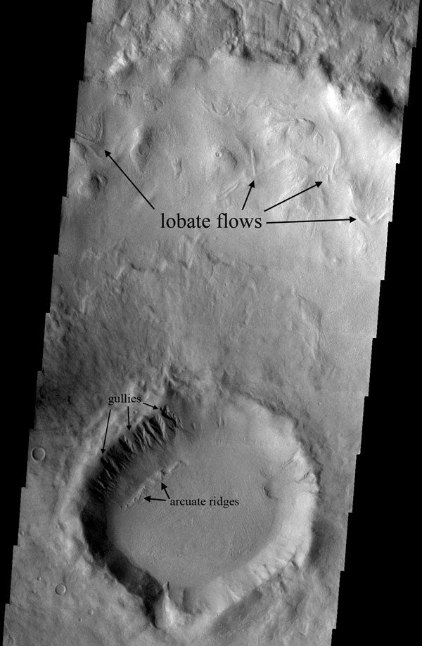
They looked specifically for the following erosional or depositional features, the number and sizes of those features, and how the features are oriented (i.e., whether they face the equator or the planet’s pole in their hemisphere):
All of these features suggest a landscape shaped by liquid water and/or ice, Berman said. He found that lobate flows, gullies, and arcuate ridges on the crater walls between latitudes of 30° to 45° face the pole in their hemisphere, whereas equator-facing orientations are more common than pole-facing ones at latitudes between 45° and 60°. In the southern study area, narrow channels generally had pole-facing orientations, whereas wider valleys generally have equator-facing orientations.
The features’ pole-facing or equator-facing orientations could result from uneven heating of the crater walls. Ice on walls that get more sunlight would melt faster, causing more water to flow and form the gullies and other features.
Unlike Earth, whose axis only oscillates through an arc of about 4° over millions of years, Mars appears to have an axis that tilts between vertical and as much as 60°, according to recent studies.
Such tilting could enhance ice deposition, Berman said. When one pole begins leaning toward the Sun, ice evaporates and then falls as snow at the other pole, which is getting little sunlight. Such tilting could have caused ice sheets to form in areas that are now ice-free, he said.
Further evidence for flowing ice is found on the crater floors, Berman said. He found that the floors of small craters slope away from the walls that exhibit erosional/depositional features toward the more pristine ones. These slopes have inclines of about 0.5° to 3°. This suggests that ice-rich materials flowed from one crater wall to the other. Tilting floors are less evident in larger craters, although some have gradually sloping floors where debris apron material is evident.
The PSI team’s crater study has led them to make the following conclusions: