New movies and images of Saturn’s moon Titan provide a bird’s-eye view of the moon’s earthlike landscape.
The new flyover maps show, for the first time, the 3-D topography and height of the 4,000-foot (1,200 meters) mountaintops, the north polar lake country, the vast dunes more than 300 feet (100 meters) high that crisscross the moon, and the thick flows that may have oozed from possible ice volcanoes.
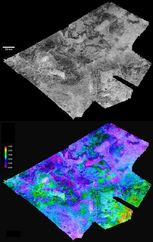
The topographic maps were made from stereo pairs of radar images.
Watch the video at saturn.jpl.nasa.gov.
Cassini radar team member Randy Kirk with the Astrogeology Science Center at the U.S. Geological Survey in Flagstaff, Arizona, created the maps. He used some of the 20 or so areas where two or more overlapping radar measurements were obtained during 19 Titan flybys. These stereo overlaps cover close to 2 percent of Titan’s surface. The process of making topographic maps from them is just beginning, but the results already reveal some of the diversity of Titan’s geologic features.
“These flyovers let you take in the bird’s-eye sweeping views of Titan, the next best thing to being there,” Kirk said. “We’ve mapped many kinds of features, and some of them remind me of Earth. Big seas, small lakes, rivers, dry river channels, mountains and sand dunes with hills poking out of them, lava flows.”
Kirk presented these results March 24 at the Lunar and Planetary Science Conference in The Woodlands, Texas.
High and low features are shown in unprecedented detail at about 1.5-mile (2.4 kilometers) resolution. The maps show some features that may be volcanic flows. These flows meander across a shallow basin in the mountains. One area suspected to be an ice volcano, Ganesa Macula, does not appear to be a volcanic dome. It may still have originated as a volcano, but it’s too soon to know for sure. “It could be a volcanic feature, a crater, or something else that has just been heavily eroded,” Kirk said.
The stereo coverage includes a large portion of Titan’s north polar lakes of liquid ethane and methane. Based on these topographical models, scientists are better able to determine the depth of lakes. The highest areas surrounding the lakes are some 4,000 feet (1,200 meters) above the shoreline. By comparing terrain around Earth to the Titan lakes, scientists estimate their depth is likely about 300 feet (100 meters) or less.
More 3-D mapping of these lakes will help refine these depth estimates and determine the volume of liquid hydrocarbons that exist on Titan. This information is important because these liquids evaporate and create Titan’s atmosphere. Understanding this methane cycle can provide clues to Titan’s weather and climate.
Launched in 1997, Cassini completed its primary 4-year mission in 2008 and is now in extended mission operations, which run through September 2010. Over the course of the mission, Cassini plans to map more than 3 percent of Titan’s surface in 3-D. About 38 percent of Titan’s surface has been mapped with radar so far. On March 27, Cassini will complete its 52nd targeted flyby of Titan.