
There will be three launch opportunities from Cape Canaveral Air Force Station in Florida at 5:12 p.m., 5:22 p.m. and 5:32 p.m. EDT
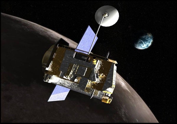
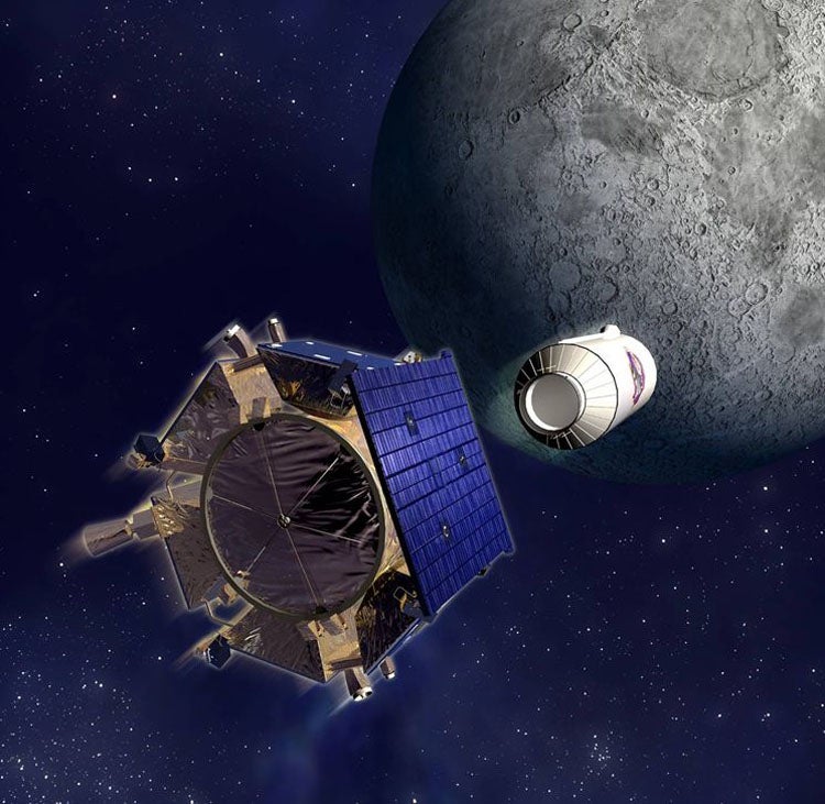
Just as a scout finds the safest way for expeditions on Earth, NASA will first send a robotic scout to prepare the way for American astronauts to return to the Moon. The Lunar Reconnaissance Orbiter (LRO) will roar into space from Cape Canaveral, Florida, on an Atlas V rocket Thursday, June 18.
LRO will orbit over the Moon’s poles, surveying surface resources and mapping potential landing sites for future piloted landings. A second craft will share the ride to the Moon — the Lunar CRater Observation and Sensing Satellite (LCROSS).
In October, LCROSS is scheduled to crash the Atlas V’s expended Centaur second stage into a permanently shadowed crater in the lunar polar regions. The shepherding spacecraft will fly through the impact plume, some 6 miles (10 kilometers) high, searching for signs of water ice.
“One of the critical things they will be looking for is evidence of water ice at the lunar poles,” says Rich Talcott, senior editor of Astronomy. “Previous science missions found tantalizing evidence for water, but it still needs to be confirmed.”
The Moon’s permanently shadowed craters may not have seen sunshine for 2 billion years. They could harbor ice deposits at -328° Fahrenheit (-200° Celsius). Water would be a valuable resource for future human exploration — to manufacture breathable oxygen, for example, and to make oxidizer for rocket fuel.
The Centaur stage will strike at an estimated velocity of 5,600 mph (9,000 km/h). The debris plume could be visible to observers on Ear th using telescopes with apertures of 10-12 inches.
The LRO carries seven instruments to identify safe landing sites for future human explorers, locate potential resources such as water, characterize the radiation environment, and test new technology. “If all goes well,” Talcott says, “NASA will bring home the best-ever global atlas of the Moon’s surface, resources, and environment.”
“Imaging will show dramatic landscapes and areas of interest down to 1-meter resolution,” adds Doug Cooke, associate administrator of NASA’s Exploration Systems Mission Directorate in Washington. “The data also will provide information about potential new uses of the Moon.”
The only people unhappy with LRO’s bounty of new data will be the conspiracy theorists who think the Apollo landings were staged. LRO’s Lunar Reconnaissance Orbiter Camera (LROC) will scan historic Apollo landing sites. LROC images should be able to capture the lunar rovers and landers of missions past.

Cosmic Ray Telescope for the Effects of Radiation (CRaTER) will characterize the lunar radiation environment, allowing scientists to determine potential hazards to astronauts.
Diviner Lunar Radiometer Experiment (DLRE) will identify cold traps — areas cold enough to preserve ice for billions of years — and potential ice deposits as well as rough terrain, rock abundance, and other landing hazards.
Lyman Alpha Mapping Project (LAMP) will search for surface ice and frost in the polar regions and provide images of permanently shadowed regions illuminated only by starlight and the glow of interplanetary hydrogen emission, the Lyman Alpha line. The bottoms of deep craters at the lunar poles might be permanently shadowed. These areas will be very cold and might hold water ice.
Lunar Exploration Neutron Detector (LEND) will create high-resolution maps of hydrogen distribution and gather information about the neutron component of the lunar radiation environment. LEND data will be analyzed to search for evidence of water ice near the Moon’s surface.
Lunar Orbiter Laser Altimeter (LOLA) will measure landing-site slopes, lunar surface roughness, and generate a high-resolution, three-dimensional map of the Moon. LOLA also will measure and analyze the lunar topography to identify the permanently illuminated and permanently shadowed areas. Certain mountain peaks at the lunar poles might be permanently illuminated. These regions may be good places for a solar power station.
Lunar Reconnaissance Orbiter Camera (NACs) on the Lunar Reconnaissance Orbiter Camera (LROC) will make high-resolution, black-and-white images of the surface, capturing images of the poles with resolutions down to 1 meter (about 3.3 feet). A third, wide-angle camera (WAC), will take color and ultraviolet images over the complete lunar surface at 100-meter (almost 330-foot) resolution. These images will show polar lighting conditions, identify potential resources and hazards, and aid selection of safe landing sites.
Miniature Radio Frequency (Mini-RF) is an advanced radar that will be used to image the polar regions and search for water ice. In addition, it will be used to demonstrate the ability to communicate with an Earth-based ground station.