With this fifth release of data, the space agency has added striking new images and maps to the already comprehensive collection of raw lunar data and high-level products, including mosaic images, that LRO has made possible. The spacecraft’s seven instruments delivered more than 192 terabytes of data with an unprecedented level of detail. It would take approximately 41,000 typical DVDs to hold the new LRO data set. “The release of such a comprehensive and rich collection of data, maps, and images reinforces the tremendous success we have had with LRO in the Exploration Systems Mission Directorate and with lunar science,” said Michael Wargo from NASA headquarters in Washington.
Among the latest products is a global map with a resolution of 109 yards (100 meters) per pixel from the Lunar Reconnaissance Orbiter Camera (LROC). To enhance the Moon’s topography on this map, LRO collected these images when the Sun angle was low. Armchair astronauts can zoom in to full resolution with any of the mosaics — quite a feat considering that each is 34,748 pixels by 34,748 pixels or approximately 1.1 gigabytes.
“Because the Moon is so close and because we have a dedicated ground station, we are able to bring back as much data from LRO as from all the other planetary missions combined,” said Richard Vondrak of NASA’s Goddard Space Flight Center in Greenbelt, Maryland.
LRO’s Diviner Lunar Radiometer Experiment is providing new data relating to the Moon’s surface. These include maps of visual and infrared brightness, temperature, rock abundance, nighttime soil temperature, and surface mineralogy. The data are in the form of more than 1,700 digital maps at a range of resolutions that researchers can easily overlay on other lunar data sets.
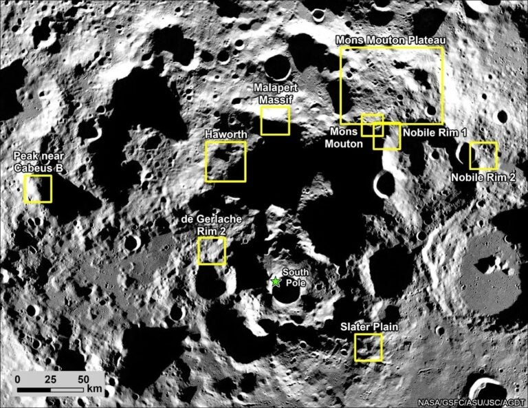
The Lyman-Alpha Mapping Project, which collects information to help identify surface water-ice deposits, especially in permanently shadowed regions of the Moon, also has new data. This release includes new maps of far-ultraviolet brightness, albedo, and water-ice data as well as instrument exposure, illumination, and other conditions.
As a complement to the high-resolution digital elevation maps, which represent 3.4 billion measurements already released by the Lunar Orbiter Laser Altimeter team, the group is delivering new maps of slope, roughness, and illumination conditions. NASA also released new maps from the Lunar Exploration Neutron Detector, and the latest data from the Cosmic Ray Telescope for the Effects of Radiation and the Miniature Radio Frequency instruments.
“All these global maps and other data are available at a very high resolution — that’s what makes this release exciting,” said Goddard’s John Keller from LRO. “With this valuable collection, researchers worldwide are getting the best view of the Moon they have ever had.”
With this fifth release of data, the space agency has added striking new images and maps to the already comprehensive collection of raw lunar data and high-level products, including mosaic images, that LRO has made possible. The spacecraft’s seven instruments delivered more than 192 terabytes of data with an unprecedented level of detail. It would take approximately 41,000 typical DVDs to hold the new LRO data set. “The release of such a comprehensive and rich collection of data, maps, and images reinforces the tremendous success we have had with LRO in the Exploration Systems Mission Directorate and with lunar science,” said Michael Wargo from NASA headquarters in Washington.
Among the latest products is a global map with a resolution of 109 yards (100 meters) per pixel from the Lunar Reconnaissance Orbiter Camera (LROC). To enhance the Moon’s topography on this map, LRO collected these images when the Sun angle was low. Armchair astronauts can zoom in to full resolution with any of the mosaics — quite a feat considering that each is 34,748 pixels by 34,748 pixels or approximately 1.1 gigabytes.
“Because the Moon is so close and because we have a dedicated ground station, we are able to bring back as much data from LRO as from all the other planetary missions combined,” said Richard Vondrak of NASA’s Goddard Space Flight Center in Greenbelt, Maryland.
LRO’s Diviner Lunar Radiometer Experiment is providing new data relating to the Moon’s surface. These include maps of visual and infrared brightness, temperature, rock abundance, nighttime soil temperature, and surface mineralogy. The data are in the form of more than 1,700 digital maps at a range of resolutions that researchers can easily overlay on other lunar data sets.
The Lyman-Alpha Mapping Project, which collects information to help identify surface water-ice deposits, especially in permanently shadowed regions of the Moon, also has new data. This release includes new maps of far-ultraviolet brightness, albedo, and water-ice data as well as instrument exposure, illumination, and other conditions.
As a complement to the high-resolution digital elevation maps, which represent 3.4 billion measurements already released by the Lunar Orbiter Laser Altimeter team, the group is delivering new maps of slope, roughness, and illumination conditions. NASA also released new maps from the Lunar Exploration Neutron Detector, and the latest data from the Cosmic Ray Telescope for the Effects of Radiation and the Miniature Radio Frequency instruments.
“All these global maps and other data are available at a very high resolution — that’s what makes this release exciting,” said Goddard’s John Keller from LRO. “With this valuable collection, researchers worldwide are getting the best view of the Moon they have ever had.”