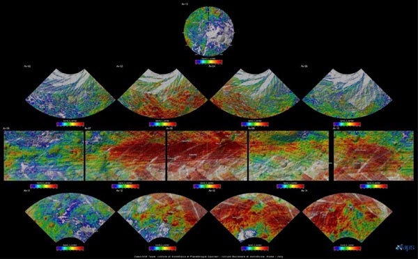
An atlas of the asteroid 4 Vesta, which scientists created from images taken during the Dawn Mission’s Low Altitude Mapping Orbit (LAMO), is now accessible for the public to explore online. The set of maps was made from mosaics of 10,000 images from Dawn’s framing camera instrument, taken at an average altitude of about 130 miles (210 kilometers).
“Creating the atlas has been a painstaking task. Each map sheet of this series has used about 400 images,” said Thomas Roatsch of the Institute for Planetary Research in Berlin. “The atlas shows how extreme the terrain is on such a small body as Vesta.”
The atlas is made of 29 maps and three different projections: Mercator projection for equatorial regions, Lambert conical projection for mid-latitudes, and stereographic projection for the Rheasilvia basin at Vesta’s south pole. Because the LAMO mapping phase took place during northern winter on Vesta, when the north pole was in complete darkness, the thirtieth tile of Vesta’s north pole is blank. A few gaps in the LAMO coverage were filled with lower resolution images taken during the High Altitude Mapping Orbit (HAMO) at 435 miles (700km) above the surface of Vesta.
In addition to the high-resolution map tiles, each of the downloadable files for the atlas also includes an index map, a perspective view, and a color-coded and shaded relief map. Scientists derived contour lines from a digital terrain model of Vesta and are based on a flattened ellipsoid 177 miles (285km) by 142 miles (229km) at its widest point.
For the purposes of the atlas, Vesta’s prime meridian passes close to the tiny crater Claudia. All positions used by the Dawn project are in that Claudia system. The names of all geological features relate to Roman Vestals, famous Roman women, cities in which the cult of Vesta is known, or festivals in which the Vestals participated. The Dawn team proposed the nomenclature, and the International Astronomical Union approved it.
To view the atlas, visit http://dawn_gis.dlr.de/atlas_dir/lamo/index.html#aricia.