perplexing-pluto-new-snakeskin-image-and-more-from-new-horizonshttps://www.astronomy.com/science/perplexing-pluto-new-snakeskin-image-and-more-from-new-horizons/Perplexing Pluto: New “snakeskin” image and more from New Horizons | Astronomy.comThe newest high-resolution images of Pluto from NASA’s New Horizons are both dazzling and mystifying, revealing a multitude of previously unseen topographic and compositional details.https://www.astronomy.com/uploads/2021/09/1_snakeskin_detail.jpgInStockUSD1.001.00exoplanetsplanets-observingrobotic-spaceflightsolar-systemarticleASY2023-05-182015-09-2437531
Perplexing Pluto: New “snakeskin” image and more from New Horizons
It's a unique and perplexing landscape stretching over hundreds of miles.
By NASA |
Published: September 24, 2015 | Last updated on May 18, 2023
The newest high-resolution images of Pluto from NASA’s New Horizons are both dazzling and mystifying, revealing a multitude of previously unseen topographic and compositional details. The image below — showing an area near the line that separates day from night — captures a vast rippling landscape of strange, aligned linear ridges that has astonished New Horizons team members.
“It’s a unique and perplexing landscape stretching over hundreds of miles,” said William McKinnon from Washington University in St. Louis. “It looks more like tree bark or dragon scales than geology. This’ll really take time to figure out; maybe it’s some combination of internal tectonic forces and ice sublimation driven by Pluto’s faint sunlight.”
The “snakeskin” image of Pluto’s surface is just one tantalizing piece of data New Horizons sent back in recent days. The spacecraft also captured the highest-resolution color view yet of Pluto, as well as detailed spectral maps and other high-resolution images.
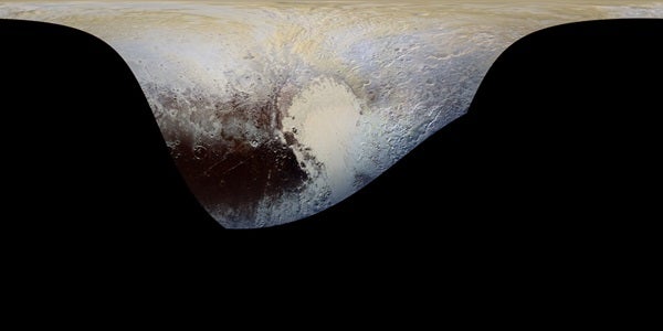
n this extended color image of Pluto taken by NASA’s New Horizons spacecraft, rounded and bizarrely textured mountains, informally named the Tartarus Dorsa, rise up along Pluto’s day-night terminator and show intricate but puzzling patterns of blue-gray ridges and reddish material in between. This view, roughly 330 miles (530 kilometers) across, combines blue, red and infrared images taken by the Ralph/Multispectral Visual Imaging Camera (MVIC) on July 14, 2015, and resolves details and colors on scales as small as 0.8 miles (1.3 kilometers).
NASA/JHUAPL/SWRI
The new “extended color” view of Pluto — taken by New Horizons’ wide-angle Ralph/Multispectral Visual Imaging Camera (MVIC) on July 14 and downlinked to Earth on Sept. 19 — shows the extraordinarily rich color palette of Pluto.
“We used MVIC’s infrared channel to extend our spectral view of Pluto,” said John Spencer from Southwest Research Institute (SwRI) in Boulder, Colorado. “Pluto’s surface colors were enhanced in this view to reveal subtle details in a rainbow of pale blues, yellows, oranges, and deep reds. Many landforms have their own distinct colors, telling a wonderfully complex geological and climatological story that we have only just begun to decode.”
This cylindrical projection map of Pluto, in enhanced, extended color, is the most detailed color map of Pluto ever made. It uses recently returned color imagery from the New Horizons Ralph camera, which is draped onto a base map of images from the NASA’s spacecraft’s Long Range Reconnaissance Imager (LORRI). The map can be zoomed in to reveal exquisite detail with high scientific value. Color variations have been enhanced to bring out subtle differences. Colors used in this map are the blue, red, and near-infrared filter channels of the Ralph instrument.
NASA/JHUAPL/SWRI
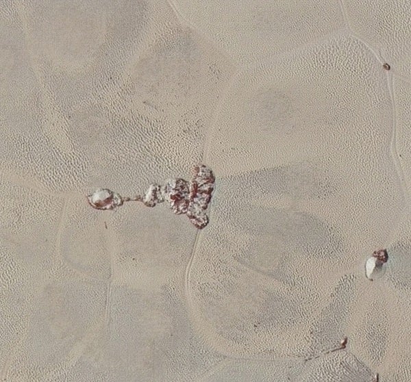
Additionally, a high-resolution swath across Pluto taken by New Horizons’ narrow-angle Long Range Reconnaissance Imager (LORRI) on July 14, and downlinked on Sept. 20, homes in on details of Pluto’s geology. These images — the highest-resolution yet available of Pluto — reveal features that resemble dunes, the older shoreline of a shrinking glacial ice lake, and fractured angular water ice mountains with sheer cliffs. Color details have been added using MVIC’s global map shown above.
High-resolution images of Pluto taken by NASA’s New Horizons spacecraft just before closest approach on July 14, 2015, reveal features as small as 270 yards (250 meters) across, from craters to faulted mountain blocks, to the textured surface of the vast basin informally called Sputnik Planum. Enhanced color has been added from the global color image. This image is about 330 miles (530 kilometers) across. For optimal viewing, zoom in on the image on a larger screen.
NASA/JHUAPL/SWRI
This closer look at the smooth bright surface of the informally named Sputnik Planum shows that it is actually pockmarked by dense patterns of pits, low ridges, and scalloped terrain. Dunes of bright volatile ice particles are a possible explanation, mission scientists say, but the ices of Sputnik may be especially susceptible to sublimation and formation of such corrugated ground.
High-resolution images of Pluto taken by NASA’s New Horizons spacecraft just before closest approach on July 14, 2015, are the sharpest images to date of Pluto’s varied terrain—revealing details down to scales of 270 meters. In this 75-mile (120-kilometer) section of the taken from the larger, high-resolution mosaic above, the textured surface of the plain surrounds two isolated ice mountains.
NASA/JHUAPL/SWRI
Beyond the new images, new compositional information comes from a just-obtained map of methane ice across part of Pluto’s surface that reveals striking contrasts: Sputnik Planum has abundant methane, while the region informally named Cthulhu Regio shows none, aside from a few isolated ridges and crater rims. Mountains along the west flank of Sputnik lack methane as well.
The distribution of methane across the surface is anything but simple, with higher concentrations on bright plains and crater rims, but usually none in the centers of craters or darker regions. Outside of Sputnik Planum, methane ice appears to favor brighter areas, but scientists aren’t sure if that’s because methane is more likely to condense there or that its condensation brightens those regions.
“It’s like the classic chicken-or-egg problem,” said Will Grundy from Lowell Observatory in Flagstaff, Arizona. “We’re unsure why this is so, but the cool thing is that New Horizons has the ability to make exquisite compositional maps across the surface of Pluto and that’ll be crucial to resolving how enigmatic Pluto works.”
“With these just-downlinked images and maps, we’ve turned a new page in the study of Pluto beginning to reveal the planet at high resolution in both color and composition,” added Alan Stern, of SwRI. “I wish Pluto’s discoverer Clyde Tombaugh had lived to see this day.”
The Ralph/LEISA infrared spectrometer on NASA’s New Horizons spacecraft mapped compositions across Pluto’s surface as it flew by on July 14. On the left, a map of methane ice abundance shows striking regional differences, with stronger methane absorption indicated by the brighter purple colors here, and lower abundances shown in black. Data have only been received so far for the left half of Pluto’s disk. At right, the methane map is merged with higher-resolution images from the spacecraft’s Long Range Reconnaissance Imager (LORRI).