Key Takeaways:

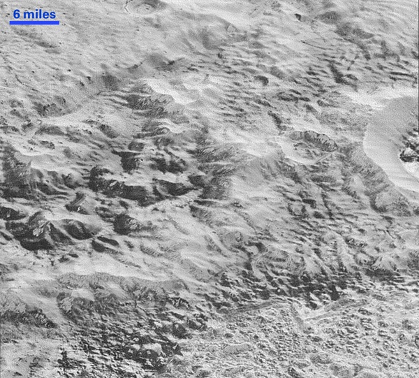
Every week the piano-sized New Horizons spacecraft transmits data stored on its digital recorders from its flight through the Pluto system on July 14. These latest pictures are part of a sequence taken near New Horizons’ closest approach to Pluto, with resolutions of about 250-280 feet (77-85 meters) per pixel, revealing features less than half the size of a city block on the diverse surface of the distant planet. In these new images, New Horizons captured a wide variety of spectacular, cratered, mountainous and glacial terrains.
“These close-up images, showing the diversity of terrain on Pluto, demonstrate the power of our robotic planetary explorers to return intriguing data to scientists back here on planet Earth,” said John Grunsfeld from NASA’s Science Mission Directorate. “New Horizons thrilled us during the July flyby with the first close images of Pluto, and as the spacecraft transmits the treasure trove of images in its onboard memory back to us, we continue to be amazed by what we see.”
“These new images give us a breathtaking, super-high resolution window into Pluto’s geology,” said Alan Stern from the Southwest Research Institute (SwRI) in Boulder, Colorado. “Nothing of this quality was available for Venus or Mars until decades after their first flybys, yet at Pluto we’re there already — down among the craters, ice fields, and mountains — less than five months after flyby! The science we can do with these images is simply unbelievable.”
The images are six times better than the resolution of the global Pluto map New Horizons obtained and five times better than the best images of Pluto’s cousin Triton, Neptune’s large moon, obtained by Voyager 2 in 1989.

“The mountains bordering Sputnik Planum are absolutely stunning at this resolution,” said New Horizons science team member John Spencer. “The new details revealed here, particularly the crumpled ridges in the rubbly material surrounding several of the mountains, reinforce our earlier impression that the mountains are huge ice blocks that have been jostled and tumbled and somehow transported to their present locations.”
These images were made with the telescopic Long Range Reconnaissance Imager (LORRI) aboard New Horizons in a timespan of about a minute on July 14 — just about 15 minutes before New Horizons’ closest approach to Pluto — from a range of just 10,000 miles (17,000km). They were obtained with an unusual observing mode. Instead of working in the usual “point and shoot,” LORRI snapped pictures every three seconds while the Ralph/Multispectral Visual Imaging Camera (MVIC) aboard New Horizons was scanning the surface. This mode requires unusually short exposures to avoid blurring the images.
Mission scientists expect more imagery from this set over the next several days, showing even more terrain at this highest resolution.
New Horizons, speeding through deep space at more than 32,000 miles (51,500km) per hour, is approximately 104 million miles (167 million km) beyond Pluto and 3.2 billion miles (5.2 billion km) from Earth. All spacecraft systems are healthy.