Get ready to go to Mars any day of the week — from your computer.
Today Google released a major update to its Mars browser that will allow you to see images taken from orbit by the Mars Odyssey spacecraft. “Some of them will only have been downloaded by NASA hours earlier,” says Michael Weiss-Malik, product manager for the Google Mars 3-D component of Google Earth. “In many cases, the user will be the first human to see the image itself.”
Related blog: “The latest Wow from Google: Mars in 3D,” by Daniel Pendick, Associate Editor
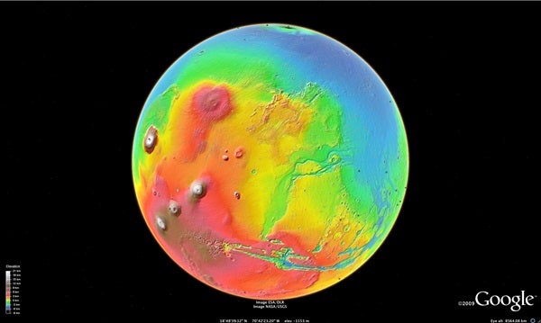
To use Google Mars 3-D, load Google Earth 5.0 (the most recent version available). Find the icon on the upper toolbar shaped like Saturn and click it. Then scroll down to “Mars” and click. You are now within a fully 3-D model of the planet Mars.
This web application is officially called “Mars in Google Earth,” but let’s call it Google Mars 3-D. In Google Earth, users can click on and off various layers — the names of major highways, for example, or historical locations. Clicking on the new layer in Google Mars 3-D called “Live from Mars” connects the browser to a live feed from NASA’s Mars Odyssey satellite, which has been orbiting the Red Planet since 2001.
The images come from Odyssey’s Thermal Emission Imaging System (THEMIS). The spacecraft loads images into memory and sends them back to Earth periodically. Google Mars 3-D will access the images automatically as the THEMIS camera team receives them.
“Live from Mars” will also be “Mars Uncensored.” Users of Google Mars 3-D will see the THEMIS portraits before scientists have processed them. “This is raw imagery,” Weiss-Malik explains. “So it’ll be the beautiful stuff as well as sort of the warts.” The images will show features on Mars as small as 330 feet (100 meters).
Still, the Odyssey feed represents the first direct connection between Mars satellite imagery and the public. When the timing is just right, users could be seeing THEMIS images within a few hours of NASA downloading them from the spacecraft. But most images will post within 12 to 24 hours of their arrival on Earth. Google worked with scientists at NASA and Arizona State University in Tempe to create the Mars Odyssey downlink for Google Mars 3-D.
NASA rebooted the Mars Odyssey spacecraft’s computers March 11 to clear a potential memory malfunction. As soon as new images download to Earth, Google Mars 3-D will post them. In the meantime, expect to see images dating to right before the planned outage/reboot.
Other new features to appear with this update include:
- Orbital tracks of the satellite’s trajectory around Mars. Images will appear at their actual location in the orbital track. The images and orbital tracks will refresh every day or two.
- Overlays on the martian surface of historical maps created by Percival Lowell (1855-1916), Giovanni Schiaparelli (1835-1910), and others, based on telescopic observations. The release of the update is timed to coincide with Schiaparelli’s March 14 birthday. (Both Lowell and Schiaparelli documented what many assumed to be canals on the surface of Mars.) Browsers will be able to toggle between the different maps and between the historical and modern surfaces of Mars.
- The trackways of the Mars Exploration Rovers Spirit and Opportunity, including the ability to see panoramic “street views” that the robots captured on their journeys.
- Guided tours of Mars narrated by Ira Flatow, host of National Public Radio’s Science Friday program, and Bill Nye the Science Guy.
The Google team’s vision for Google Mars 3-D is as a browser for a planet. And the door is open for anyone to create and distribute additional layers for the Google Mars 3-D universe using the keyhole markup language (KML) originally developed for use with Google Earth, Weiss-Malik says. “Our hope is that [NASA] will leverage it increasingly to inject their own content. They don’t have to go through Google.”
Using KML, non-scientists can also create new content for Google Mars 3-D. A thriving community already exists on the Internet that creates and exchanges KML layers for Google Earth. A similar community could develop for Google Mars 3-D. “Anyone who wants to can be the first person to create, say, the Viking image layer,” Weiss-Malik says. “They can import oodles of data we haven’t gotten around to doing yet.”
Google also hopes scientists will begin to communicate new findings using Google Mars 3-D, either in the form of KML documents or on web pages. “We would love for people to use us as their publishing tool for their scientific results,” says Noel Gorelick, technical lead for the Google Astro team. “When you’ve got a scientific result that’s easily expressed in a 3-D form, we’re a great way to include that in your publication.”
Ultimately, Google Mars 3-D is about seeing the planet in a new way. “This increases your ability to understand and see the information,” Weiss-Malik says.


