The MESSENGER mission was designed to answer several key scientific questions, including the nature of Mercury’s geological history. Remote sensing of the surface’s chemical composition has a strong bearing on this and other questions. Since MESSENGER was inserted into orbit about Mercury in March 2011, data from the spacecraft’s X-Ray Spectrometer (XRS) and Gamma-Ray Spectrometer (GRS) have provided information on the concentrations of potassium, thorium, uranium, sodium, chlorine, and silicon, as well as ratios relative to silicon of magnesium, aluminum, sulfur, calcium, and iron.
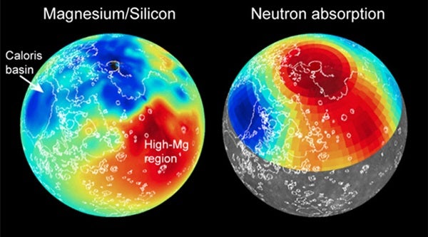
Until now, however, geochemical maps for some of these elements and ratios have been limited to one hemisphere and have had poor spatial resolution. In “Evidence for Geochemical Terranes on Mercury: Global Mapping of Major Elements with MESSENGER’s X-Ray Spectrometer,” the authors used a novel methodology to produce global maps of the magnesium/silicon and aluminum/silicon abundance ratios across Mercury’s surface from data acquired by MESSENGER’s XRS.
These are the first global geochemical maps of Mercury and the first maps of global extent for any planetary body acquired via the technique of X-ray fluorescence, by which X-rays emitted from the Sun’s atmosphere allow the planet’s surface composition to be examined. The global magnesium and aluminum maps were paired with less spatially complete maps of sulfur/silicon, calcium/silicon, and iron/silicon, as well as other MESSENGER datasets, to study the geochemical characteristics of Mercury’s surface and to investigate the evolution of the planet’s thin silicate shell.
The most obvious of Mercury’s geochemical terranes is a large feature, spanning more than 2 million square miles (5 million square kilometers). This terrane “exhibits the highest observed magnesium/silicon, sulfur/silicon, and calcium/silicon ratios, as well as some of the lowest aluminum/silicon ratios on the planet’s surface,” said Shoshana Weider from the Carnegie Institution of Washington. Weider and colleagues suggest that this “high-magnesium region” could be the site of an ancient impact basin. By this interpretation, the distinctive chemical signature of the region reflects a substantial contribution from mantle material that was exposed during a large impact event.
A second paper, “Geochemical Terranes of Mercury’s Northern Hemisphere as Revealed by MESSENGER Neutron Measurements,” presents the first maps of the absorption of low-energy — thermal — neutrons across Mercury’s surface. The data used in this second study were obtained with the GRS anti-coincidence shield, which is sensitive to neutron emissions from the surface of Mercury.
“From these maps, we may infer the distribution of thermal-neutron-absorbing elements across the planet, including iron, chlorine, and sodium,” said Patrick Peplowski of the Johns Hopkins University Applied Physics Laboratory in Laurel, Maryland. “This information has been combined with other MESSENGER geochemical measurements, including the new XRS measurements, to identify and map four distinct geochemical terranes on Mercury.”
According to Peplowski, the results indicate that the smooth plains interior to the Caloris basin, Mercury’s largest well-preserved impact basin, have an elemental composition that is distinct from other volcanic plains units, suggesting that the parental magmas were partial melts from a chemically distinct portion of Mercury’s mantle. Mercury’s high-magnesium region, first recognized from the XRS measurements, also contains high concentrations of unidentified neutron-absorbing elements.
“Earlier MESSENGER data have shown that Mercury’s surface was pervasively shaped by volcanic activity,” said Peplowski. “The magmas erupted long ago were derived from the partial melting of Mercury’s mantle. The differences in composition that we are observing among geochemical terranes indicate that Mercury has a chemically heterogeneous mantle.”
“The consistency of the new XRS and GRS maps provides a new dimension to our view of Mercury’s surface,” Weider said. “The terranes we observe had not previously been identified on the basis of spectral reflectance or geological mapping.”
“The crust we see on Mercury was largely formed more than three billion years ago,” said Carnegie’s Larry Nittler. “The remarkable chemical variability revealed by MESSENGER observations will provide critical constraints on future efforts to model and understand Mercury’s bulk composition and the ancient geological processes that shaped the planet’s mantle and crust.”

