Titan’s dynamic realm

Cassini's radar experiment turns up tantalizing clues that Saturn's biggest moon is geologically active.
By | Published: September 27, 2005 | Last updated on May 18, 2023

September 27, 2005
With each orbital pass by Saturn’s planet-size moon Titan, NASA’s Cassini spacecraft reveals more territory. Following the third radar-mapping pass, completed September 7, scientists are piecing together clues of a geologically active world. Beneath the thick orange fog, Cassini has charted windswept areas resembling desert sands, canyons cut by some kind of fluid, and mountains with vast flows of material.
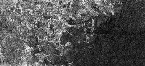
Titan shoreline
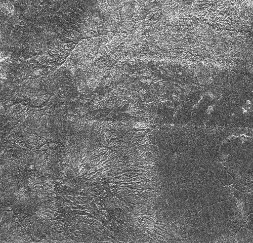
This Synthetic Aperture Radar image of the surface of Saturn’s moon Titan was obtained by the Cassini spacecraft on Sept. 7, 2005. The bright, rough region on the left side of the image seems to be topographically high terrain that is cut by channels and bays.
NASA/JPL
One area of Titan displays a flat, nearly featureless zone abutting a rougher highland. “We see something that looks like a lake shore,” team member Rosaly Lopes told Astronomy. She cautions: “I don’t know if there is liquid there now or not.” This “shore” cuts into the higher ground in a series of bays and spreading channels. The boundary between the two terrains indicates the lowland may have been flooded in the past. The liquid, perhaps methane, may have retreated, or it may be invisible to Cassini’s radar eye.

Scientists so far have identified two types of drainage erosion on Titan. The first is a series of deeply cut channels roughly 0.6 mile (1 kilometer) across and 650 feet (200 meters) deep. These valleys are long, tracking as far as 120 miles (200 km) across the icy surface. The angular canyons have few tributaries and seem to follow faults in Titan’s crust.

Titan drainage channels
This bright terrain is cut by channels that are variable in width; they form both radial and branching networks. This Cassini Synthetic Aperture Radar image of Titan was taken on Sept. 7, 2005, at a distance of 2,000 kilometers (1,250 miles).
NASA/JPL
The second type of drainage pattern is a set of radially branching networks. These valleys drape across the bright, rugged terrain in patterns similar to those left by rainfall here on Earth. The gullies spread out toward the dark plains similar to river deltas on Earth, widening as they reach a lake or ocean. One theory proposes that organic soot, precipitating out of the atmosphere, has been washed from the highlands by methane rain. The dark material then collects across the lowlands.

Another telltale sign of Titan’s geologic activity plays out as cryovolcanism, or ice volcanoes. Researchers note a large circular structure about 110 miles (180 km) across, provisionally called Ganesa Macula. The domed feature has radar-bright flanks radiating from a central depression. This depression could be an eroded impact crater, but Lopes believes it bears the profile of a volcanic caldera. “It definitely looks cryovolcanic. There is a dome, similar to the pancake domes on Venus, with large flows.” The flows stretch 55 miles (90 km) to the southeast, apparently transporting material along the mountain’s flanks.

Titan’s cryovolcanoes could be triggered by tidal heating — the flexing of interior material resulting from Titan’s elliptical orbit around Saturn. Along with the channels, ridges, and valley networks, Titan’s landscape bears witness to a dynamic, active world.

Michael Carroll is a science writer and astronomical artist, and author of nearly 20 children’s science books. He lives with his family in Colorado.