Catherine Weitz, a senior scientist at the Planetary Science Institute in Tucson, Arizona, has reported new evidence for multiple, water-related geologic processes on Mars.
She and her colleagues studied light-toned deposits (LTDs) within troughs of the Noctis Labyrinthus region in western Valles Marineris using data gathered by three Mars Reconnaissance Orbiter (MRO) instruments: the High Resolution Imaging Science Experiment (HiRISE) camera, the Context Camera (CTX), and the Compact Reconnaissance Imaging Spectrometer for Mars (CRISM).
“We analyzed ten troughs containing well-exposed LTDs, and we found a lot of variability that we didn’t expect to see,” Weitz said. “We found that each of the troughs with LTDs has a unique mineralogy, and, therefore, the processes occurring in each trough were very localized.”
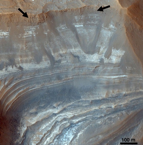
Weitz and her team identified various types of clays, hydrated silicas, and sulfates in these small basins, which are typically 19 to 62 miles (30 to 100 kilometers) across. One LTD included dozens of beds of varying thickness, brightness, color, and erosional structure, suggesting that significant amounts of water once existed there. In addition, sulfates were mixed with clays within the deposits, indicating that ph levels may have fluctuated between acidic and alkaline conditions.
Another LTD is buried several meters beneath wind-deposited material and is only exposed in the trough’s upper walls, indicating it is older than the trough. In still another area, clays are buried beneath younger plains along the trough floor, while in the same trough, but a few miles away, there are exposures of hydrated silica and calcium sulfate.
The wide variability in deposits and mineralogy in these and other basins suggests a complex hydrologic history, including multiple events in some troughs, Weitz said.
“Clearly, these areas were affected by water,” she said. “In some cases there had to be multiple events. But we don’t know how much water was involved or whether it was always a flowing liquid.”
“It might have been groundwater coming from Tharsis, the large volcanic complex to the west,” she said. “There could have been active volcanism that produced water by melting snow, ice, or underground, hydrothermal processes. These little basins could then have filled or partially filled with some of that water. Another possibility is that material was already in several of the troughs, perhaps as volcanic ash or lava flows, and some kind of hydrothermal activity may have altered these pre-existing deposits.”
Weitz and her colleagues identified LTDs using the wide-range CTX camera that covers about a 19 mile (30 km) swath at a spatial resolution of 20 feet (6 meters) per pixel. Then they zeroed in on the areas of interest using HiRISE visible light images that cover about a 3-mile-wide (5 km) area with a resolution of about 10 inches (26 centimeters) per pixel.
Finally, the corresponding CRISM data — in the visible and near infrared regions — revealed the hydrated minerals within each LTD.
“It’s great to have these complementary data sets,” Weitz said. “Together, the synthesis of these three data sets provides valuable morphologic and mineralogic information needed to interpret the geologic setting and origin of the light-toned deposits within the troughs of Noctis.”
The LTDs both pre-date and post-date trough formation and occurred between the Noachian (4.6 to 3.5 million years ago) and Amazonian (1.8 billion years ago to the present) eras. The sediments in the LTDs could have formed at the bottom of lakes or pools, but materials also could have been deposited by the wind or fallen as volcanic ash and then been altered by water.
Noctis Labyrinthus is a region of Mars that’s located between the volcanic Tharsis upland and Valles Marineris, a huge system of canyons.

