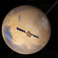
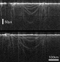
Mars Express, a European Space Agency (ESA) spacecraft orbiting the Red Planet, used the Mars Advanced Radar for Subsurface and Ionospheric Sounding (MARSIS) to provide the first three-dimensional views beneath the Red Planet’s surface. Using radar, MARSIS probed the planet’s subsurface and revealed ancient, buried craters. Such findings will help scientists better understand the planet’s geologic evolution.
The data revealed a hidden, 155-mile-diameter (250 kilometers) depression in Chryse Planitia. Although the basin isn’t buried deeply, it is invisible from the surface. MARSIS’ ground-penetrating radar shows distinctive arcs that correspond to ring structures, and a flat feature nearly 100 miles (160 km) long.
“[The detection of buried impact basins] may force us to reconsider our chronology of the formation and evolution of the surface,” comments MARSIS’ co-principal investigator Jeffrey Plaut of NASA. Previously, the only ways to look into Mars’ geologic history were by analyzing exposed layers in crater or valley walls, or drawing cross-sections based on surface maps.
ESA has extended Mars Express’ mission for another martian year, roughly 2 Earth years, beginning in December, in part to allow MARSIS to continue searching for water. Mars Express arrived at the Red Planet in December 2003, but concerns about how some instruments might affect the spacecraft delayed MARSIS’ use. MARSIS has been collecting data for roughly 5 months in 30-minute intervals three times a day during as many orbits as possible.

