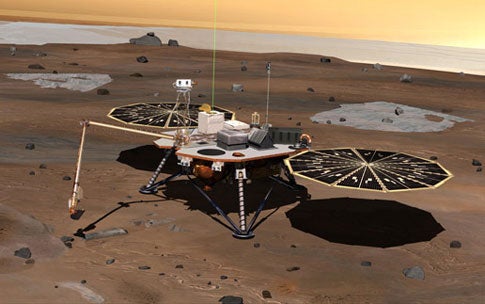
NASA’s latest effort to search for water on Mars launches August 4. The Phoenix mission will then blast off from Cape Canaveral, Florida, on its way to Mars’ frigid arctic. With help from its soil-scooping, telescoping arm, the craft’s onboard science lab will see if conditions favorable to earthlike life exist or have existed in the past. Phoenix will also monitor the martian polar climate.
The mission is the first attempt to actually collect and analyze martian water, in the form of buried ice. Past research indicates large areas of Mars, such as the arctic plains, have water ice just below the surface. The lander’s robotic arm can dig as deep as 20 inches (50 cm).
Scientists would like to know if frozen water near the martian surface periodically melts, creating a livable environment for microbes. If so, the lander may find evidence of the arctic’s “water history” based on clues in the soil.
“Phoenix has been designed to examine the history of the ice by measuring how liquid water has modified the chemistry and mineralogy of the soil,” says Peter Smith, the Phoenix principal investigator at the University of Arizona, Tucson.
Upon arrival in May 2008, the craft will attempt a risky descent and landing using rocket thrusters. The Viking landers, which touched down in 1976, were the last Mars missions to attempt this type of landing with rockets. NASA’s Mars Polar Lander was supposed to land the same way but is assumed to have crashed after a malfunction.
Phoenix uses a heat shield to slow its high-speed entry, followed by a supersonic parachute that further reduces its speed to about 135 mph (216 kph). The lander then separates from the parachute and fires pulsed descent rocket engines to slow to about 5.5 mph (8.8 kph) before landing on its three legs. With its side-mounted solar panels unfurled, the lander is about 18 feet (5.5 meters) wide and 5 feet (1.5 meters) long.
An instrument called the Mars Descent Imager was supposed to take about 20 pictures as Phoenix landed. The images would provide information about the environment in which the lander conducted its studies.
However, mission scientists determined that data from the camera could have interfered with the craft’s gyroscopes on the way down, possibly leading to a crash. Instead, the camera will take one image at low altitude, supplemented by additional imaging by NASA’s Mars Reconnaissance Orbiter.
Researchers evaluating possible landing sites have used observations from Mars orbiters to find the safest places where the mission’s goals can be met. The leading candidate site is a broad valley with few boulders at a latitude equivalent to northern Alaska.

